Maritime areas are areas of the sea for which international law provides for the boundaries of these areas and the rights that different categories of States can exercise in it. The legal nature or status of a maritime zone, which is the object of overlapping claims, pending delimitation, is particularly relevant for the process of negotiating and establishing the maritime boundary.
This article will provide information about UNCLOS Maritime Zones in the context of the IAS Exam.
This article is useful for GS Paper-II of the UPSC Syllabus.
The candidates can read more relevant information from the links provided below:
| United Nations Organisation | International Maritime Organization |
| International Seabed Authority (ISA) | India’s Deep Ocean Mission – DOM | Ministry of Earth Sciences (MoES) |
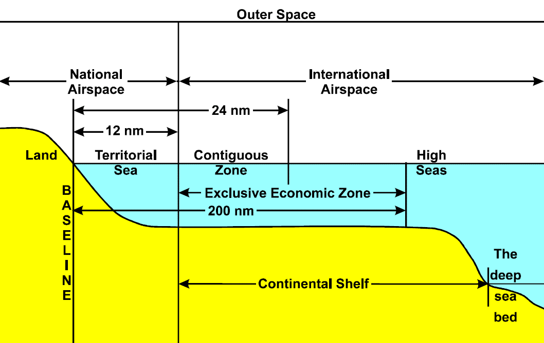
Maritime Zones under UNCLOS
UNCLOS sections the oceans, splitting marine areas into the following zones, each with a different legal status:
- Internal Waters
- Archipelagic Waters
- Territorial Sea
- Contiguous Zone
- Exclusive Economic Zone
- Continental Shelf
- High Seas
Source – MRAG Website
Internal Waters
- Ships entering internal waters must conform with the rules and regulations of the coastal or port State (Port State Control).
- Waters on the landward side of the baseline of the territorial sea form part of the internal waters of the State.
- In the case of ships proceeding to internal waters or a call at a port facility outside internal waters, the coastal State also has the right to take the necessary steps to prevent any breach of the conditions to which admission of those ships to internal waters or such a call is subject.
- No right of innocent passage except where the use of territorial sea straight baselines encloses waters not previously internal waters.
Archipelagic Waters
- The archipelagic baselines must include the main islands.
- The archipelagic baselines must enclose an area of the sea at least as large as the area of enclosed land but not more than nine times that of the land area.
- No archipelagic baseline may exceed 100 nautical miles in length; except that up to 3 per cent of the total number of baselines enclosing any archipelago may exceed that length, up to a maximum length of 125 nautical miles.
- The archipelagic baselines must not depart to any appreciable extent from the general configuration of the archipelago.
Territorial Sea
- No right of overflight in the territorial sea.
- The sovereignty of a coastal State extends, beyond its land territory and internal waters and, in the case of an archipelagic State, its archipelagic waters, to an adjacent belt of sea, described as the territorial sea.
- This sovereignty extends to the airspace over the territorial sea, as well as to its bed and subsoil.
- The sovereignty over the territorial sea is exercised subject to this Convention and to other rules of international law.
Contiguous Zone
- The contiguous zone is the zone contiguous to the territorial sea where a coastal State may exercise control for preventing and punishing infringement of its laws and regulations concerning customs, fiscal, immigration or sanitary matters within its territory or territorial sea as well as the removal of archaeological and historical objects found at sea.
- May not extend beyond 24 nautical miles from territorial sea baselines.
Exclusive Economic Zone
- The breadth of the exclusive economic zone shall not extend beyond 200 nautical miles from the baselines from which the breadth of the territorial sea is measured.
Continental Shelf
- The coastal States exercise over the continental shelf, which comprises the seabed and subsoil of the submarine areas that extend beyond its territorial sea, exclusive sovereign rights for the purpose of exploring it and exploiting its natural resources.
- The continental margin comprises the submerged prolongation of the landmass of the coastal State and consists of the seabed and subsoil of the shelf, the slope and the rise. It does not include the deep ocean floor with its oceanic ridges or the subsoil thereof.
To read more about Ocean Floor And Its Features, check the linked article.
High Seas
- The high seas are open to all States, whether coastal or land-locked.
- The high seas shall be reserved for peaceful purposes.
- No State may validly purport to subject any part of the high seas to its sovereignty.
- Every State, whether coastal or land-locked, has the right to sail ships flying its flag on the high seas.
| Kickstart your IAS preparation now and complement it with the links given below: |
United Nations Convention on the Law of the Sea (UNCLOS) – 3 Important Articles
- Every state can claim a territorial sea up to 12 nautical miles as per Article 3 of the United Nations Convention on the Law of the Sea (UNCLOS).
- Article 7 of the UNCLOS gives guidelines on Straight Baselines.
- Article 5 of the UNCLOS gives guidelines on Normal Baseline, Article 3 of the UNCLOS gives information on the Breadth of the Territorial Sea.
About UNCLOS:
To read more about the United Nations Convention on the Law of the Sea (UNCLOS), check the linked article. |
United Nations Convention on the Law of the Sea (UNCLOS) – 3 Different Conferences
- The first conference on UNCLOS was held in Geneva, Switzerland, in 1956.
- UNCLOS – I led to the conclusion of four treaties in 1958, but these treaties came into force in different years. These 4 treaties were the Convention on Fishing and Conservation of Living Resources of the High Seas, Convention on the Continental Shelf, Convention on the High Seas, Convention on the Territorial Sea and Contiguous Zone.
- UNCLOS – II was held in 1960. However, this second conference did not lead to the conclusion of any new treaties.
UNCLOS – III: Important Outcomes
- The Third United Nations Conference on the Law of the Sea convened in New York in 1973 after different claims on territorial waters were made by different nations.
- This conference lasted until 1982.
- Many important provisions were introduced by this convention, they were – settlement of disputes, scientific research, deep seabed mining, protection of the marine environment, continental shelf jurisdiction, the exploitation regime, navigation, exclusive economic zones (EEZs), and navigation.
UNCLOS – III: Limits of Various Maritime Zones
Continental shelf – Maritime Zone
- Coastal states have the right to harvest non-living material and minerals in the subsoil of its continental shelf.
- A state’s continental shelf may exceed 200 nautical miles (370 km) until the natural prolongation ends.
Exclusive economic zones (EEZs) – Maritime Zone
- To stop the increasingly heated clashes over fishing rights, the EEZ’s were introduced.
- In casual use, the Exclusive economic zones (EEZs) may include the continental shelf and territorial sea.
- Within Exclusive economic zones (EEZs), the sole rights of exploitation over all natural resources will be given to the coastal nation.
- Exclusive economic zones (EEZs) extends up to a distance of 200 nautical miles from the baseline.
Territorial waters – Maritime Zone
- Up to 12 nautical miles from the baseline is known as the territorial waters.
UNCLOS Maritime Zones [UPSC Notes]:-Download PDF Here
Frequently Asked Questions on United Nations Convention on the Law of the Sea (UNCLOS)
What are the maritime zones under the UNCLOS?
The maritime zones recognized under international law include the continental shelf, the exclusive economic zone (EEZ), the territorial sea, the contiguous zone, internal waters, the high seas and the Area.
What is an example of a maritime boundary?
Australia–France Marine Delimitation Agreement is an example of a maritime boundary.
Other related links:
Comments